· 13 min read
Define Pressure Altitude: Formula and Aviation Use
Define pressure altitude as the altimeter reading at 29.92 inHg. Learn the formula, a correction table and why pilots use it in flight planning.
Pressure altitude is the altitude an altimeter displays when its barometric scale is set to 29.92 inches of mercury, which equals 1,013.2 millibars, the standard sea-level pressure of the International Standard Atmosphere. That single setting converts an ordinary instrument reading into a shared reference, and it's the number nearly every performance chart assumes you've already worked out.
So why does a value that isn't your height above anything sit at the top of a takeoff distance table?
Because the atmosphere moves. Local pressure drifts hour by hour, so an altimeter dialed to the local setting answers a different question every time: how high am I above the sea-level pressure somebody measured nearby? That's the right question for terrain and traffic, and the wrong one for comparing your airplane against a chart built in a lab-standard air mass. Students meet this gap on their first warm afternoon at a high field, when the runway eats an extra thousand feet and the altimeter never mentioned a thing. Learning to define pressure altitude precisely, as a reference rather than a height, is what closes it.
Table of Contents
- What Pressure Altitude Means in Plain Terms
- How to Calculate Pressure Altitude Step by Step
- Five Altitudes Pilots Mix Up and How They Differ
- Why Pressure Altitude Drives Performance and Flight Levels
- Transponder Altitude Versus Your Cockpit Altimeter
- Worked Pairs for the Written Exam
What Pressure Altitude Means in Plain Terms
Pressure altitude is the altitude an altimeter shows when you rotate its barometric scale to 29.92 inHg, or 1,013.2 millibars. The FAA Aviation Weather Handbook ties that figure to the standard sea-level pressure of the International Standard Atmosphere and names the level it measures from as the standard datum plane, a theoretical surface where pressure equals 29.92 inHg.
Picture a race where every runner starts from the same painted line instead of their own doorstep. Flyers need that same courtesy. One shared zero is what lets a chart developed for a trainer in Kansas mean something to a pilot over the desert. The standard datum plane is that zero, an imaginary line that floats slightly below, at, or above physical sea level depending on the day, and it doesn't matter which, because every aircraft measures from the same one.
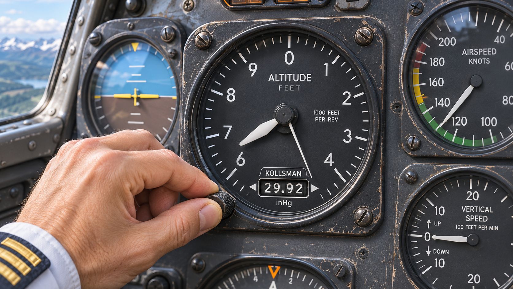
What the reading does not tell you matters just as much. Set 29.92 and see 6,500 feet, and the FAA is careful with its wording: the sensed atmospheric pressure corresponds to 6,500 feet in the standard atmosphere, not necessarily that the airplane is physically 6,500 feet above the terrain. Pressure altitude is a pressure-based reference. It is not a geometric measurement of height above ground or above mean sea level, which is why you can log 6,500 feet over flat farmland and over a mountain ridge without changing a thing.
Say it this way: pressure altitude is what you read when the altimeter is set to standard pressure, not where you are above the ground.
The FAA calls the definition foundational for a practical reason. Performance charts, flight levels, and most of the arithmetic you'll do before departure need one consistent pressure reference rather than whichever local setting happens to be current at your airport.
How to Calculate Pressure Altitude Step by Step
How do you turn the altimeter setting into pressure altitude without reversing the correction? You can use the altimeter itself, apply a formula, or work backward from measured pressure. The FAA Pilot's Handbook of Aeronautical Knowledge altimeter chapter defines pressure altitude as the altitude in the International Standard Atmosphere associated with the pressure sensed by the instrument. Set 1,013.2 hPa, or 29.92 inHg, and the altimeter shows that reference regardless of the actual local setting. The knob gives a direct reading; the formula is quicker, but its sign is easy to get wrong.
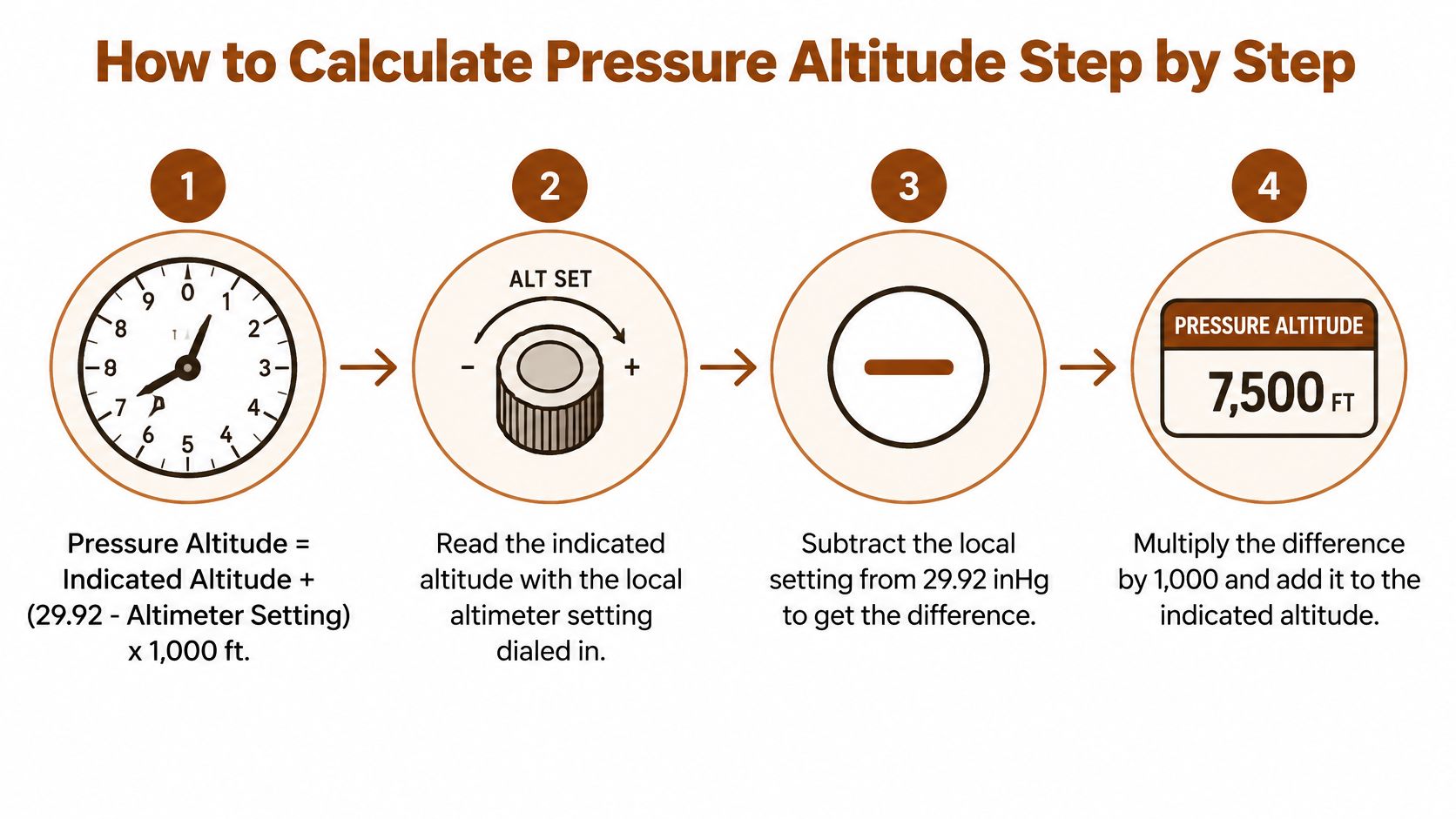
Pressure altitude = indicated altitude + (29.92 - altimeter setting) x 1,000 feet
The five steps with real numbers
- Read indicated altitude with the local setting dialed in. Suppose the altimeter shows 5,000 feet. That is the indicated altitude, which is not the pressure altitude you are calculating.
- Get the current altimeter setting. Use ATIS at a towered field or AWOS or ASOS at a nontowered one. For this example, use 30.42 inHg.
- Subtract the setting from 29.92. 29.92 - 30.42 = -0.50.
- Multiply the difference by 1,000 feet per inch of mercury. -0.50 x 1,000 = -500 feet.
- Add the correction to indicated altitude. 5,000 + (-500) = 4,500 feet.
The negative correction lowers the result. That is the sign check: a setting above 29.92 lowers pressure altitude, while a setting below 29.92 raises it.
Where the correction table does the same work
Pressure altitude corrections for an indicated altitude of 5,000 feet
| Altimeter setting (inHg) | Correction (feet) |
|---|---|
| 28.92 | +1,000 |
| 29.42 | +500 |
| 29.92 | 0 |
| 30.42 | -500 |
| 30.92 | -1,000 |
| 31.42 | -1,500 |
Read down the correction column to see the pattern. As the setting rises above 29.92, the correction becomes more negative, so pressure altitude falls below the indicated altitude. Below 29.92, the correction is positive. At 29.92, it is zero because the altimeter is already set to standard pressure.
The formula's 1,000-foot factor is a rule of thumb: pressure falls roughly 1 inHg per 1,000 feet of climb. The relationship shifts with altitude and weather, so the formula is an approximation, not a precise measurement. It works for a quick mental check, but a small-aircraft performance decision should use the appropriate calculation rather than rely on the shortcut.
When the shortcut is not enough
As altitude and temperature move away from standard conditions, the shortcut becomes less dependable. For a more exact calculation, use a flight computer; this guide to using an E6B flight computer explains the steps for working with pressure altitude and outside air temperature to find true airspeed.
Two habits help keep the numbers straight. In the air, set 29.92 and read the pressure altitude, then restore the local setting before using the altimeter for terrain reference. On the ground, compare the formula with the value from your app. If a low setting produces a correction that barely changes the result, check the subtraction and the sign.
Five Altitudes Pilots Mix Up and How They Differ
The fastest way to stop mixing these up is a lookup table that answers one question per row: what is this altitude referenced to?
| Altitude | Reference point | What it tells you | Where pilots use it |
|---|---|---|---|
| Indicated altitude | Current local altimeter setting | Altimeter reading in the cockpit | Traffic and terrain checks in the pattern |
| Pressure altitude | 29.92 inHg (1,013.2 mb) standard datum | Atmospheric pressure in standard-atmosphere terms | Performance inputs and flight levels above 18,000 ft |
| Density altitude | Pressure altitude corrected for temperature | Air density as the engine and wings experience it | Takeoff distance and climb performance |
| True altitude | Mean sea level in actual conditions | Height above mean sea level in real air | Terrain clearance and approach planning |
| Height above ground | Terrain or obstacle beneath the aircraft | Distance to the ground below | Landing flare and obstacle clearance |
Now put two aircraft in the air. Both level off showing the same indicated altitude in different regions, one under a 30.42 setting and one under 29.92. Their altimeters agree, their pressure altitudes don't, and neither pilot has made a mistake. Then hold that pressure altitude steady while the afternoon warms. Density altitude climbs, the takeoff roll grows, and no pressure value changed at all.
That pair of aircraft is exactly the separation the FAA Pilot's Handbook of Aeronautical Knowledge chapter on altimeters draws when it explains why pressure altitude feeds density altitude, true airspeed, and aircraft performance instead of standing in for them.
Charts don't ask where you are. They ask what the atmosphere is doing where you are.
Pilots keep pressure altitude as the base because it standardizes the pressure half of the problem. Temperature, weight, and runway condition get layered on afterward, and the chart stays usable precisely because its starting reference never changes. When a term still feels slippery, the flyCowboys aviation glossary keeps each definition short enough to check on the ramp before a flight.
Why Pressure Altitude Drives Performance and Flight Levels
Performance charts don't begin with your location. They begin with pressure altitude, the pressure input, and temperature, which together become density altitude. The FAA Pilot's Handbook of Aeronautical Knowledge chapter on aircraft performance lists it as the basis for calculating density altitude, true altitude, true airspeed, and related operating values.

What thin air costs you
As pressure altitude rises, air density generally falls, and four things follow in order:
- Engine output: thinner air carries less oxygen mass into the cylinders on each intake stroke, so the engine burns less fuel and makes less power.
- Propeller thrust: a propeller working in thin air accelerates less mass rearward, so thrust drops for the same rpm.
- Wing lift: for a given true airspeed, less dense air generates less lift, which is why the wing wants more speed or more runway.
- Runway distance: takeoff and landing distances both grow as the pressure reference climbs.
The runway itself never moves. Say an airport sits at a surveyed field elevation of 4,000 feet MSL, and a low-pressure day pushes pressure altitude to 5,500 feet. Your airplane doesn't know the survey number. It performs as if it were sitting at 5,500 feet, and the chart you open reflects that, which is why a high field plus a low barometer produces a high-pressure-altitude departure even though nobody changed the airport.
The relationship is easier to watch in motion than to read in a table.
Why flight levels exist
At and above 18,000 feet MSL in the United States, aircraft set 29.92 inHg and report flight levels, so FL180 means a nominal pressure altitude of 18,000 feet. Because every aircraft uses the same pressure reference, traffic separates vertically even when surface pressure differs from region to region. The switch into that structure is worth reviewing alongside the airspace rules that govern it, since the transition point is where local settings and standard settings hand off.
Before you open the chart: confirm the pressure altitude first, then read the numbers. The chart was drawn for that reference, not for your field elevation.
Transponder Altitude Versus Your Cockpit Altimeter
If the number on your altimeter and the number on the controller's scope disagree, one of you must be wrong. Usually neither is, and the reason is a split reference that catches nearly every student at least once.
FAA air traffic guidance states that altitude-reporting transponders transmit pressure altitude, and that ATC automation applies the current altimeter setting to that pressure-altitude signal to display altitude above mean sea level. Two references, one transmission, and a controller looking at the corrected result.
The consequence is worth saying plainly. Change the setting in the Kollsman window and your indicated altitude moves. The transponder's transmitted pressure altitude doesn't, because that value never depended on your window setting in the first place.
Say you level at flight level 180 with 29.92 in the window. The station below reports 30.12. Automation applies that local value to your pressure-altitude signal and presents ATC with a slightly different MSL figure than the round 18,000 on your dial. Both are correct. They answer different questions, and nobody needs to key a microphone to sort it out.
Why standardize up high at all? At those altitudes, the standard setting helps eliminate errors that arise from different station barometers, geographical sources, and some instrument effects. Every aircraft in the same block of air is measuring from the same zero, which is the only way vertical separation by a few hundred feet makes sense.
Pressure altitude also is not a GPS altitude or a terrain measurement. It depends on sensed static pressure and the altimeter system, so a blocked static port corrupts it exactly the way it corrupts your cockpit reading. Treat it as an instrument-derived reference, not a satellite fix.
Where does the handoff happen? At the transition altitude for your region, pilots flying below it use the local setting because they need terrain and traffic accuracy, and pilots above it set 29.92 and speak in flight levels. The two numbers can look different and both be right.
Worked Pairs for the Written Exam
Three fresh pairs, worked straight through, make the formula automatic.
- 4,000 feet indicated at 29.42. 29.92 - 29.42 = 0.50, times 1,000 = +500, so pressure altitude is 4,500 feet.
- 6,500 feet indicated at 30.12. 29.92 - 30.12 = -0.20, times 1,000 = -200, so pressure altitude is 6,300 feet.
- 2,000 feet indicated at 28.92. 29.92 - 28.92 = 1.00, times 1,000 = +1,000, so pressure altitude is 3,000 feet.
Verify any of them by spinning a practice altimeter to 29.92 and reading the same figure.
On an exam item, decide first whether the question wants indicated, pressure, or density altitude, then multiply. Pressure altitude is only the pressure input. A hot day pushes density altitude above that number and stretches the takeoff roll without touching the pressure value. Above 18,000 feet in the United States the setting is already 29.92, so the flight level you're assigned is the pressure altitude and no correction applies.
Write the sign in words once and the error stops: higher than 29.92 means subtract, lower than 29.92 means add. If you want that rule to become reflex, our practice questions are written by active DPEs and CFIs who update them monthly, and every practice exam uses the same layout as the PSI screen at the testing center.
Pressure altitude questions run through the performance, weather, and flight-planning areas of both the Private Pilot and Instrument Rating knowledge tests, and they reward steady repetition more than a memorized formula. flyCowboys builds that repetition into an iPhone app with adaptive drills that target your weak topics, a Readiness Score that tells you when you're close to scheduling, and full-length practice exams in the PSI layout. Work a few sets of altitude and performance questions there, and the sign rule stops being something you recite and becomes something you see.