· 16 min read
Airspace Rules Explained: FAA Classes and Requirements
Learn FAA airspace rules for every class, VFR weather minima and ADS-B requirements, plus a step-by-step way to check a route before you fly.
The sectional is spread across the FBO's picnic table, and you've just drawn a pencil line from your home airport to a grass strip 85 nautical miles east. The line climbs out of a Class D surface area, passes through Class E at 9,500 feet, and clips the corner of a blue dashed shape you can't quite name. Your instructor taps the chart and asks one question: at that corner, what are you allowed to do?
You know the answer is printed somewhere on that sheet. You're less sure the sheet tells you everything. That's the honest starting point for almost every student, and it's where airspace stops being a memorization exercise and becomes a decision process.
Think of airspace as a version-controlled system. The class gives you the baseline rules. The current chart edition, the charted procedures drawn on it, the NOTAMs issued this morning, and the exact wording of the clearance you receive decide what you may do in the next hour. Miss the first layer and you'll fail the written exam. Miss the others and you'll bust airspace.
Table of Contents
- Airspace Classes at a Glance
- How the FAA Organizes Controlled and Uncontrolled Airspace
- VFR Visibility and Cloud Clearance by Altitude
- ADS-B and Transponder Requirements Along Your Route
- How to Check a Route Against Airspace Rules Step by Step
- Misreading Charts, Clearances and Drone Authorizations
- Student Pilot Endorsements and Next Steps
Airspace Classes at a Glance
The class you're in decides which rules apply first. Picture a building where each floor opens with a different key: you can't argue your way through the door on floor four with the key for floor two. The chart labels the floor. The regulation tells you what the key looks like.
Find your row by working from most restrictive to least.
| Class | Where it applies | Entry requirement | Equipment or radio |
|---|---|---|---|
| A | 18,000 ft MSL up to FL600 | IFR flight plan and ATC clearance | Two-way radio, transponder, ADS-B Out |
| B | Surface to 10,000 ft MSL around the busiest airports, in shelves | ATC clearance | Two-way radio, transponder, ADS-B Out |
| C | Surface to 4,000 ft above airport elevation | Two-way radio contact before entry | Two-way radio, transponder, ADS-B Out |
| D | Surface to 2,500 ft AGL around towered airports | Two-way radio contact before entry | Two-way radio |
| E | Usually 1,200 ft AGL, 700 ft AGL in some areas, up to 18,000 ft MSL | No clearance needed for VFR | Transponder and ADS-B Out at or above 10,000 ft MSL |
| G | Surface up to 1,200 ft AGL, uncontrolled | None | None beyond general VFR rules |
Reading the differences that matter
Class A is the flight levels, and it's closed to VFR traffic entirely. If your route needs 18,000 feet, you need an instrument rating, an IFR flight plan and a clearance.
Class B is the one that requires an explicit clearance before entry, not just a radio call. The shelves mean the boundary can step down in rings around the primary airport, so a route at 6,000 feet may be inside Class B while the same ground track at 3,000 feet is not.
Classes C and D ask for two-way radio communication before entry. That's a lower bar than a clearance, but it has a specific meaning: the controller must use your call sign in the reply. "Aircraft calling, stand by" doesn't establish communication.
Class E is the confused middle. Most of it is the 1,200 ft AGL shelf above Class G, but it also comes down to the surface at some airports and exists along federal airways. No clearance and no radio call is required for VFR.
Class G is uncontrolled airspace near the ground. Nothing to request, and nothing beyond the general VFR rules.
Notice what the table leaves out. It doesn't give weather minima, altitude-based equipment thresholds, or the difference between a radio call and a clearance. Those layers come next, and each one changes what the class label alone seemed to promise.
Before every flight, find each segment's class on the sectional. The class sets the first set of rules you must meet, not the only one.
How the FAA Organizes Controlled and Uncontrolled Airspace
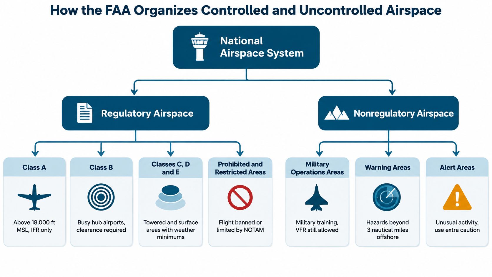
The FAA splits the National Airspace System into two categories, regulatory and nonregulatory, and four functional types: controlled, uncontrolled, special-use and other. Regulatory airspace covers Classes A, B, C, D and E plus prohibited and restricted areas. The nonregulatory side holds military operations areas, warning areas, alert areas, controlled firing areas and national security areas, per the FAA's Airman's Information Manual, Chapter 3.
The reason any of this exists sits above the FAA. The 1944 Chicago Convention established that every state has "complete and exclusive sovereignty" over the airspace above its territory, which is why each country writes its own entry rules and why crossing a border means diplomatic clearance, flight plans and customs.
Here's how the two branches and four types fit together.
The overlap rule students forget
Picture four transparent map sheets stacked on a light table, each printed with one airspace area. Where two sheets overlap, the darker, more restrictive print wins. The FAA builds that hierarchy deliberately: when designations overlap, the more restrictive rule applies, with Class A more restrictive than B, C, D, E or G, and Class B more restrictive than C, D, E or G.
A real example makes it concrete. Say a Class D airport sits underneath a shelf of Class B. The chart still prints the Class D label, and the tower still answers your call, but at that location the Class B rules govern what you must do. Students fly the Class D procedure and get violated by the Class B requirement, because they read the label nearest the airport instead of the most restrictive one covering the point.
Chart versus regulation: the chart tells you which class touches your route. The regulation tells you what that class requires of your aircraft, your certificate and your weather minimums.
The FAA is explicit that the exact dimensions, exceptions, geographic boundaries and equipment requirements live in Title 14 of the Code of Federal Regulations. The chart is a depiction, not the authority. If a charted boundary and the regulation appear to disagree, the regulation wins and you should be asking why your chart is out of date.
One habit to build now: in any busy chart area, list every class that overlaps your route and name the one that governs. Do it aloud. If you can't name the governing class in two seconds, you don't yet understand that piece of the map.
VFR Visibility and Cloud Clearance by Altitude
There's no such thing as "the VFR minimum." There's a minimum for the class you're in and the altitude band you're in, and the answer changes as you climb.
| Airspace and altitude | Flight visibility | Cloud clearance |
|---|---|---|
| Classes C, D and E below 10,000 ft MSL | 3 statute miles | 500 ft below, 1,000 ft above, 2,000 ft horizontal |
| Classes C, D and E at or above 10,000 ft MSL | 5 statute miles | 1,000 ft below, 1,000 ft above, 1 statute mile horizontal |
| Class B below 10,000 ft MSL | 3 statute miles | Clear of clouds |
| Class G above 1,200 ft AGL, below 10,000 ft MSL (day) | 1 statute mile | 500 ft below, 1,000 ft above, 2,000 ft horizontal |
| Class G at or below 1,200 ft AGL (day) | 1 statute mile | Clear of clouds |
Why the altitude band changes the answer
The FAA's VFR weather minimum guidance sets the basic standard at 3 statute miles visibility with 500 feet below, 1,000 feet above and 2,000 feet horizontally in Class C, D and E below 10,000 feet MSL. At and above 10,000 feet MSL, the standard rises to 5 statute miles with 1,000 feet below, 1,000 feet above and 1 statute mile horizontally. The reasoning is speed and reaction time: aircraft up high move faster, so everyone gets more room.
Now watch how that catches a student. Say the forecast is 4 statute miles visibility and scattered clouds with bases at 6,000 feet. Your planned cruise at 9,500 feet MSL is legal. Same route, same weather, and you decide to climb to 10,500 feet for smoother air. You're now noncompliant, because the band above 10,000 feet wants 5 statute miles. Nothing changed outside the window. Your altitude did.
A route is legal segment by segment, not as an average. One number never covers a whole cross-country.
Rows that students skip
The single row for Classes C, D and E does not describe Class B, and it doesn't describe Class G. Class B has its own entry requiring 3 statute miles and clear of clouds below 10,000 feet MSL, and Class G has separate day minimums that depend on whether you're above or below 1,200 feet AGL. Applying the C/D/E row to a Class B transit is one of the most common written-exam errors, and it's easy to spot once you've done it wrong on a practice test.
Then there's the forecast side. Reading a METAR and TAF properly means pulling the visibility, the ceiling and the layer heights apart, then matching each one to the band your route crosses.
For practical planning, trace every altitude and lateral segment against the sectional's airspace shelves before departure. Compare forecast and observed visibility and cloud bases with the minima for that exact band, not with a remembered number.
ADS-B and Transponder Requirements Along Your Route
A clearance does not settle your equipment. That assumption causes real violations, because ATC is responsible for separating traffic, not for telling you that your aircraft configuration fails an airspace rule. You can be legally cleared into airspace you're not legally equipped to enter.
The FAA's equipment and airspace requirements set ADS-B Out in Class A, B and C airspace, above the ceiling and within the lateral boundaries of Class B or C up to 10,000 feet MSL, and in Class E at or above 10,000 feet MSL within the contiguous United States and the District of Columbia, except at or below 2,500 feet AGL. The installed system must use a position source meeting the performance requirements of 14 CFR 91.227.
Separately, an operable altitude-reporting transponder is generally required at and above 10,000 feet MSL in the same region, excluding airspace at or below 2,500 feet above the surface.
The shelf that catches pilots
Consider a flight that crosses above a Class B area at 11,000 feet and never touches the surface area or the shelves themselves. It looks like a clean overflight of nothing in particular. It still triggers ADS-B, because the rule covers the airspace above the ceiling and within the lateral boundaries up to 10,000 feet MSL. The same logic applies to a route that passes over a Class C area without entering it at low altitude.
Equipment check: read the floor, the ceiling and the lateral boundaries of each segment, then ask what equipment those three numbers demand.
Three checks before you launch. Confirm the floor, ceiling and lateral boundaries of every segment so you know which equipment thresholds you cross. Verify your ADS-B configuration before departure, including the position source, because an aircraft that's compliant on paper can still squawk the wrong settings. And if a deviation is needed, request it from ATC, knowing that it's only lawful where the regulation allows and operationally sensible where it's granted.
Pilots who plan around equipment instead of reacting to it never have this conversation on frequency.
How to Check a Route Against Airspace Rules Step by Step
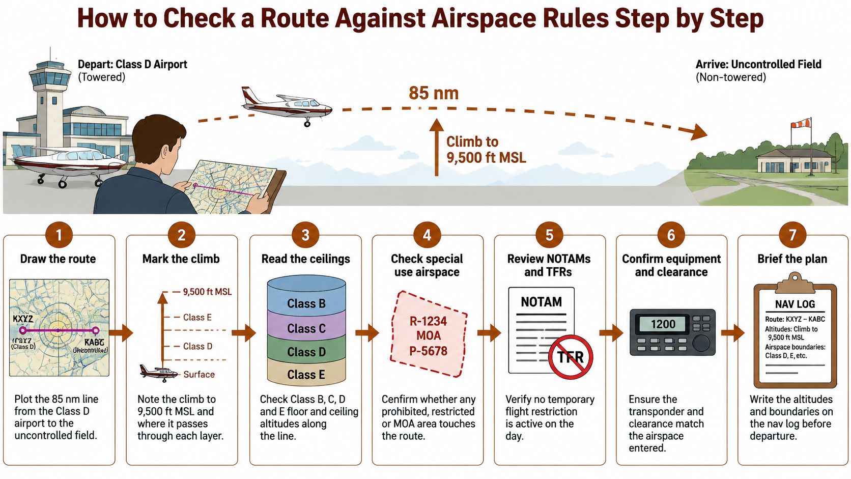
Take the 85 nautical mile cross-country from a towered Class D airport to an uncontrolled field, with a climb to 9,500 feet MSL on the way. That's a typical student route, and it touches more rules than most students expect.
Run the route like a software update check. The class printed on the chart is only the version label. The current chart edition, the procedures charted along your line and the exact wording of each clearance decide what you're allowed to do. The six steps below reconcile all three in about fifteen minutes.
Work through them in order, because each step depends on the one before it.
- Mark every leg on the sectional. Draw the actual line, not a rough idea of it, and note each shelf, surface extension and boundary it crosses. A route that clips the corner of a shelf changes the rules for that segment, and a two-mile deviation may not move you out of it.
- Record the floor and ceiling for each segment. The altitude band decides which class governs, so a segment at 3,500 feet and the same segment at 9,500 feet can carry different requirements. Write both numbers on the nav log next to the leg they belong to.
- Check equipment rules for high or complex segments. Any portion at or above 10,000 feet MSL, and any portion inside Class B or C limits, can trigger transponder and ADS-B obligations whether or not you ever talk to ATC.
- Compare forecast visibility and cloud bases with each band's minima. One number does not cover the whole route. If the climb to 9,500 feet puts you near a ceiling, decide on the ground where you'll level off or turn back.
- Pull the NOTAMs and temporary flight restrictions, and confirm the chart edition. A stadium TFR on a Saturday afternoon changes the whole plan. An expired chart is last season's version of the airspace, and it can hide a new transition route or a moved boundary.
- List the frequencies and the clearance each controlled segment needs. Note the Class D tower frequency, the approach or center frequency for the Class E above it, and the diversion airport you'd use if the weather sours. When the clearance comes back, read it for exactly what it grants, because that wording is the final authority over what you filed.
Reading the symbology is its own skill, and our guide to how to read a sectional chart walks through the markings that trip people up on shelves and surface extensions.
If you want a controller's-eye version of the same planning, this walkthrough pairs well with the steps above.
When the list is done, the route plan shows every item checked on paper, with altitudes, boundaries and frequencies written next to each leg. That paper becomes your working copy of the airspace as it exists on the current edition.
Misreading Charts, Clearances and Drone Authorizations
A current chart can still be read wrong. Trouble starts when a pilot treats the class letter as the whole rulebook. Airspace behaves like version control: the class is the release name, and the chart edition, charted procedures and clearance wording are the commit that sets your actual permission.
Misreading one is believing airspace classes never change. The FAA's February 2025 AIM update revised guidance on charted VFR products, including Flyway and VFR Transition Routes built for areas with high traffic volume and complex airspace. A transition you memorized last year can be redrawn, renamed or moved to a different shelf edge. Fix: fly from the current edition and brief the exact line you will use, not the line you remember.
Misreading two is hearing “cleared approach” and filling in the rest. The same update clarified that a “cleared approach” without a specified procedure leaves a visual or contact approach outside that clearance. If the controller's wording is thin, ask for the exact procedure before you descend. Fix: read the clearance for the authority it grants, then read back the piece you need spelled out.
Misreading three is assuming drone authorization changes crewed duties. The FAA has begun approving some commercial drone operations without visual observers. That widens who may operate; your scan, see-and-avoid discipline and separation decisions stay with you. Fix: mark reported drone activity as workload, then keep eyes outside.
Version control is the habit: current edition, current procedures, exact clearance. When a call is ambiguous, use our guide to radio procedure.
Student Pilot Endorsements and Next Steps
A student pilot can be legal at the departure airport and still be short of legal for the airspace ahead. The certificate sets one layer; the endorsement, the current sectional, the charted procedure and the exact words of the clearance set the rest.
Before any flight or study session, run the same five-point check: class, visibility and cloud minima, equipment rules, required clearance or radio contact, and chart and NOTAM currency for every segment.
What changes as a student is paperwork that must match the exact airspace you plan to enter. You need the appropriate instructor endorsement before solo cross-country under 14 CFR 61.93, and Class B solo work carries its own instruction and logbook requirements under 14 CFR 61.95. Ask your CFI to walk the route's airspace with you before any solo flight, then confirm each endorsement names the make and model, the route or operating area, and the Class B airport or airspace you intend to use. An endorsement for the local practice area does not stretch to a Class B transition 60 miles away.
Official sources settle anything a study guide leaves open: the current sectional, the AIM, the NOTAM system and Title 14 of the CFR. When those four disagree with a prep book, the prep book is wrong.
Pick one route from your own training and run the six-step check on it. For each controlled segment, write down the endorsement required, the clearance or radio contact needed, and the chart edition you used. Then brief it with your instructor before you fly it.
If you'd rather study airspace rules with questions that look and feel like the official exam instead of rereading a chapter, flyCowboys covers classifications, weather minimums, regulations and radio work in one iPhone subscription built around the FAA Airman Certification Standards. The study plan starts from zero and builds in order, bite-sized sessions fit between flight lessons, adaptive drills keep weak areas coming back, and practice exams are laid out like the PSI screen at the testing center. Visit flyCowboys to start your personalized study plan and work through your first airspace set today.