· 18 min read
How to Read METAR and TAF Reports for Pilots
Learn how to read METAR and TAF reports step by step: decode wind, visibility, ceilings and TAF time groups before you fly.
You're checking the weather before a training flight, and the airport report looks manageable until you reach BKN008. The forecast mentions TEMPO, your arrival falls near a change group, and suddenly the question isn't just what the abbreviations mean. It's whether the weather leaves enough room for your flight, your airplane, and your experience.
Learning how to read METAR and TAF reports means making two passes through the information. First, decode what the report says. Then ask what those conditions mean for runway choice, visibility, approaches, fuel, alternates, and the option to wait.
Table of Contents
- METAR and TAF Decoder for Every Common Element
- How to Decode a METAR Line by Line
- Ceilings, Visibility and Flight Categories
- Reading TAF Time Groups and Change Indicators
- Mistakes and Go or No-Go Calls Under Forecast Uncertainty
- Annotated TAF and ACS-Style Practice Decodes
- Confirm the Decode Before Your Next Flight
METAR and TAF Decoder for Every Common Element
A METAR is an observation, while a TAF is a forecast. NOAA's aviation weather guide describes METARs as generally hourly observations and TAFs as forecasts for an area within 5 statute miles of the airport center.
That distinction changes how you read them. Start with the observation's timestamp, then compare its wind, visibility, weather, and clouds with the forecast conditions applicable at that time. A favorable forecast doesn't erase an unfavorable observation.
Recognize the groups before interpreting them
Use the following hypothetical KDEN training report as a reference. The separate variable-wind example illustrates an alternative wind group, not an additional wind condition in that report.
METAR elements and what each code means
| Element | Example code | What it means |
|---|---|---|
| Station | KDEN |
ICAO identifier for Denver International Airport. Confirm you've selected the intended airport before planning around its weather. |
| Day and time | 191853Z |
Observation on the nineteenth at 18:53 UTC. Its age matters when conditions are changing. |
| Wind | 27015G25KT |
Wind from 270 degrees true at 15 knots, gusting to 25 knots. Use direction and gusts when evaluating runway alignment and crosswind exposure. |
| Variable wind | VRB03KT |
Direction varies, speed 3 knots. Don't assume a steady headwind from a favorable direction. |
| Visibility | 1 1/2SM |
One and a half statute miles of reported prevailing visibility. Consider what that means for navigation and the intended operation. |
| Weather | -RA BR |
Light rain with mist. Identify both precipitation and anything obscuring visibility. |
| Sky condition | BKN008 OVC025 |
Broken at 800 feet, overcast at 2,500 feet above ground level. The lower broken layer establishes the ceiling. |
| Temperature and dewpoint | M02/M08 |
Minus 2°C temperature, minus 8°C dewpoint. Consider moisture, freezing conditions, and the broader weather picture together. |
| Altimeter | A2992 |
Altimeter setting of 29.92 inches of mercury. This is a pressure setting, not an altitude. |
| Remarks | RMK AO2 |
Automated station with a precipitation discriminator. Remarks provide reporting-system information and additional weather detail. |
These examples use U.S.-style reporting conventions. International reports share much of the same vocabulary, but visibility units, pressure groups, and supplementary information can differ.
Read combinations, not isolated codes
A wind group helps you evaluate runway suitability, but it doesn't tell you whether you can see the runway. Likewise, a comfortable temperature-dewpoint separation doesn't cancel a reported low ceiling.
Keep a dependable reference beside your practice reports. Our aviation weather book guide can help you choose material for studying the weather processes behind the abbreviations.
Practical rule: Find the element, decode its value, then read it alongside the surrounding conditions. No isolated group describes the whole flight environment.
How to Decode a METAR Line by Line
Work through this hypothetical training report in the same order every time:
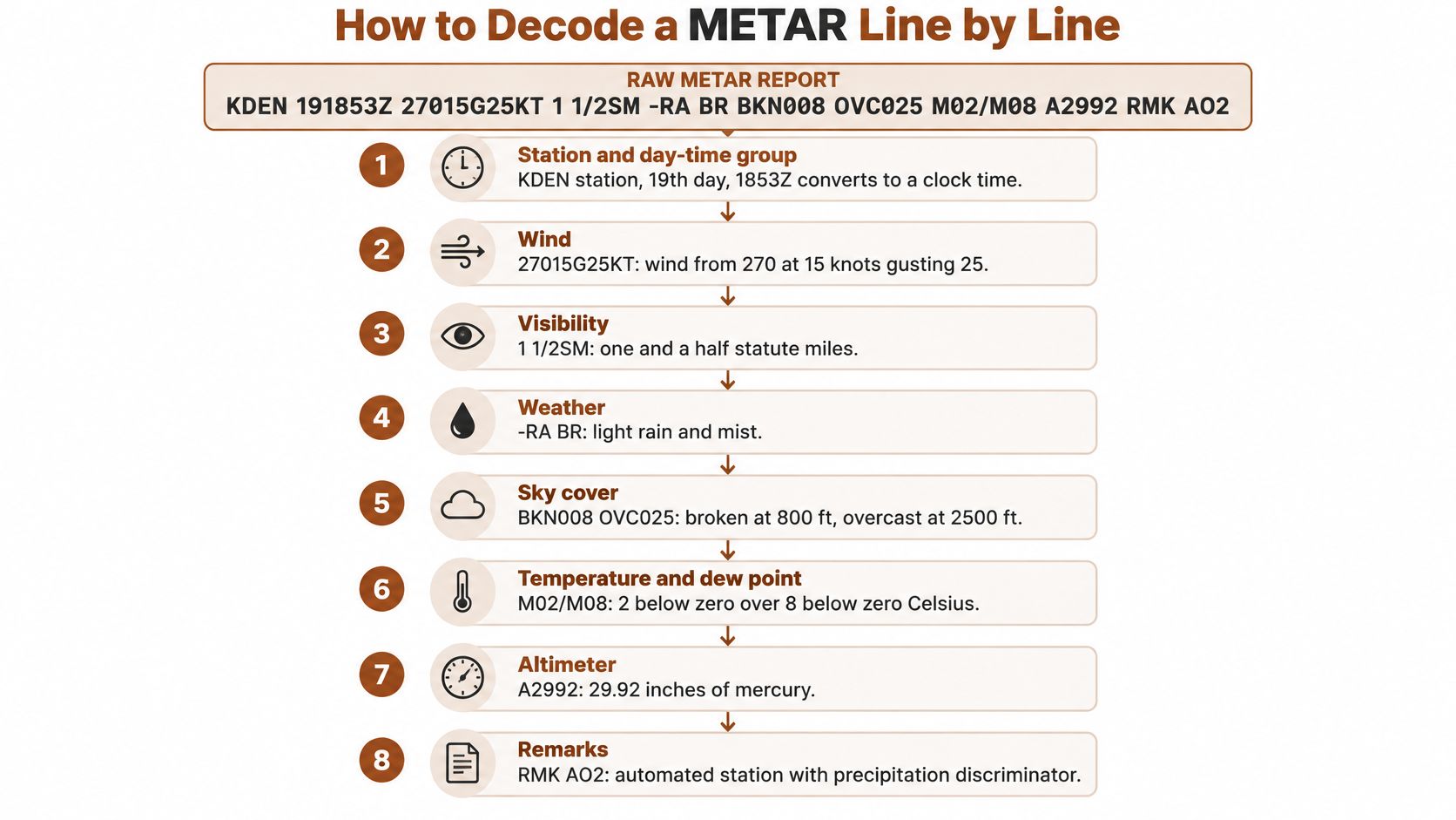
KDEN 191853Z 27015G25KT 1 1/2SM -RA BR BKN008 OVC025 M02/M08 A2992 RMK AO2
Treat it as a decoding exercise, not a verified historical observation. Some training strings combine conditions that deserve extra scrutiny, so successful decoding should lead to questions, not automatic acceptance.
Follow a fixed reading order
Identify the airport and observation time.
KDENidentifies Denver International, and191853Zmeans the nineteenth day of the month at 18:53 UTC. The usual slip is comparing that timestamp with a local departure time without accounting for the date and time-zone difference.Read the wind direction, speed, and gusts.
27015G25KTmeans wind from 270 degrees true at 15 knots, gusting to 25 knots. In this example, the gust spread is 10 knots, which deserves attention when assessing handling demands, but it isn't a measurement of turbulence along the route.Keep the visibility fraction together.
1 1/2SMmeans one and a half statute miles, not two separate visibility values. Don't confuse statute miles with nautical miles or assume the prevailing visibility guarantees the same view in every direction.Separate intensity from weather type.
In-RA BR, the minus sign makes the rain light,RAmeans rain, andBRmeans mist. Light precipitation doesn't necessarily mean easy flying, especially when the accompanying obscuration limits visibility.Find the lowest ceiling layer.
BKN008 OVC025describes a broken layer at 800 feet AGL and an overcast layer at 2,500 feet AGL. The ceiling is the lower broken layer, not the higher overcast layer, and neither height is an altitude above mean sea level.Read each temperature sign independently.
M02/M08means temperature minus 2°C and dewpoint minus 8°C, a separation of 6°C in this example.Mmeans minus, not missing; also, the subfreezing temperature paired with reported rain warrants checking the actual report and freezing-precipitation information rather than casually accepting the string.Recognize the pressure setting.
A2992means 29.92 inches of mercury for altimeter adjustment. Don't read it as airport elevation, and don't substitute a remembered standard setting for the current setting required by your operation.Read the remarks without overinterpreting them.
RMKintroduces remarks, andAO2identifies an automated station equipped with a precipitation discriminator. That describes equipment capability, not a guarantee that every precipitation type or nearby hazard has been perfectly identified.
Use this visual to rehearse the sequence without skipping the final groups.
Make the operational pass
The low ceiling and restricted visibility put this example in IFR-category weather. The gusts and subfreezing temperature add separate planning concerns that a category label won't capture.
Your instructor's next question shouldn't be “Can you expand every abbreviation?” It should be “Which part of your planned flight changes because of this report?”
Ceilings, Visibility and Flight Categories
The ceiling is the lowest layer reported as broken or overcast, or the reported vertical visibility into an obscuration. A few clouds or a scattered layer alone doesn't establish a ceiling.
Cloud-cover abbreviations describe how much of the sky is covered. FEW means a small amount, SCT means scattered coverage, BKN means more extensive broken coverage, and OVC means overcast. Those descriptions help you interpret the view, but the ceiling designation is what matters when applying the category comparison.
Compare ceiling and visibility separately
The following reference distinguishes weather categories, not the complete legal requirements for operating under visual or instrument flight rules.
Flight categories by ceiling and visibility
| Flight category | Ceiling | Visibility | Planning meaning |
|---|---|---|---|
| VFR | Above 3,000 ft AGL | Above 5 SM | Visual-category weather, but terrain, airspace, hazards, and personal margins still require evaluation. |
| MVFR | 1,000 to 3,000 ft AGL | 3 to 5 SM | Marginal conditions. Evaluate terrain clearance, escape options, and deterioration risk. |
| IFR | 500 to below 1,000 ft AGL | 1 to below 3 SM | Instrument-category weather. Check applicable qualifications, equipment, approaches, and alternate requirements. |
| LIFR | Below 500 ft AGL | Below 1 SM | Low instrument conditions. Approach availability and diversion margins may sharply limit options. |
The more restrictive element sets the category. Don't average a good ceiling with poor visibility or choose whichever value makes departure look easier.
For a hypothetical example, clear skies with 2 statute miles visibility still produce IFR-category weather. Conversely, excellent visibility below a low broken layer doesn't turn the airport into VFR-category weather.
A weather category is a screening tool, not a flight authorization. It doesn't establish that a particular route, aircraft, or pilot can safely complete the flight.
Look beyond the category color
METARs don't provide a complete icing or turbulence assessment. Subfreezing temperatures with visible moisture deserve an icing review; gusty winds and changing directions deserve attention to handling demands and possible turbulence.
Use the appropriate additional products:
- AIRMETs and SIGMETs identify relevant broader-area hazards.
- PIREPs describe conditions pilots encountered, subject to their location, altitude, and age.
- Forecast graphics and winds aloft help connect airport conditions with the route and cruising altitude.
A green airport symbol doesn't promise smooth air or an ice-free climb. A low category doesn't tell you whether the available approach is usable, either.
When departure, destination, or alternate conditions are restrictive, evaluate approaches, terrain, equipment, and diversion choices before departure, while changing the plan remains straightforward.
Reading TAF Time Groups and Change Indicators
Begin with the validity period, not the most reassuring weather group. The FAA Aeronautical Information Manual explains that 0918/1024 runs from 1800Z on the ninth through 2400Z on the tenth, and that most TAFs cover 24 hours, with selected airports using 30-hour forecasts.
The same FAA guidance lists scheduled issuance at 0000Z, 0600Z, 1200Z, and 1800Z. Issue time and validity start are different fields, so don't assume the forecast begins when it was published.
Understand what each change group changes
An ending hour of 24 means midnight at the end of the stated date. It doesn't add another day.
TAF change indicators and how to plan around them
| Indicator | What it signals | How to use it in planning |
|---|---|---|
FM |
A new set of prevailing conditions from a specific time | Replace the earlier prevailing forecast; retain the new conditions until subsequently changed. |
BECMG |
Gradual change across the stated period | Evaluate both the earlier and later conditions, especially when the transition affects your margins. |
TEMPO |
Temporary fluctuations during the stated window | Account for the temporary conditions without treating them as the prevailing forecast throughout the window. |
PROB30 or PROB40 |
The encoded probability of the specified conditions | Treat the conditions as a planning risk, not a promise that they will or won't occur. |
TAF AMD |
An amended forecast | Use the amendment immediately rather than continuing to plan from the superseded forecast. |
FM is a reset of prevailing conditions. Read the complete new group rather than carrying favorable details forward from the opening forecast.
BECMG describes a transition, not a precise appointment with better weather. If your arrival depends on improvement, don't assume it will occur at the beginning of that transition window.
TEMPO modifies the relevant elements temporarily. Unchanged elements remain applicable, and a temporary deterioration still matters if it overlaps your approach.
Regional practices differ, so you won't necessarily encounter every indicator in every country's TAFs.
The timeline visual helps distinguish a change at a point from a change across a window.
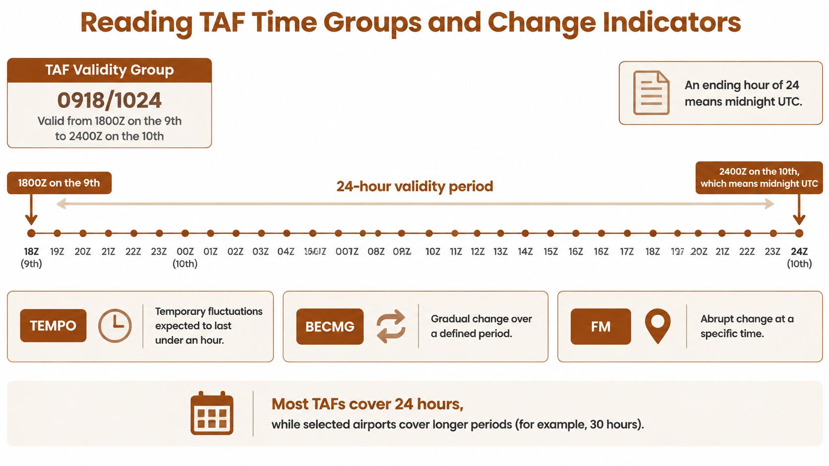
Put the flight on the forecast timeline
Consider a hypothetical 1400Z departure and 1800Z arrival, with a temporary deterioration during 1600Z to 1800Z. The departure uses the prevailing group covering departure, while the arrival deserves scrutiny because its timing sits against the deterioration window.
Don't interpret the boundary as an assurance that conditions will improve exactly when you arrive. An early arrival, delayed approach, or later-than-expected weather change can alter the exposure.
Write down:
- Departure time and its applicable prevailing conditions.
- Route checkpoints where other weather products must support the plan.
- Arrival window, including temporary conditions and nearby transitions.
That written timeline prevents you from selecting good weather from the wrong part of the forecast.
Mistakes and Go or No-Go Calls Under Forecast Uncertainty
A correctly decoded destination TAF still isn't a route briefing. The Aviation Weather Center's data guidance distinguishes airport reports and forecasts from the additional products needed to understand the wider weather situation.
Reviewing the report alongside the route helps expose what the airport forecast cannot answer.

Resolve apparent disagreements correctly
When a routine METAR, a SPECI, and an amended TAF differ, they aren't competing versions of the same information. The newest applicable observation describes observed conditions; the newest forecast describes expected conditions.
A SPECI is a special observation issued between routine reports when relevant conditions warrant it. The WMO's aerodrome reports and forecasts update addresses METAR, SPECI, TREND, and TAF together, including the role of amended forecasts.
Say an observation shows visibility substantially worse than the TAF anticipated. Don't dismiss the observation because the forecast looks better, and don't assume the observation proves all later forecast periods wrong.
Instead, ask whether the deterioration is spreading, persisting, or appearing at nearby stations. Pair the reports with radar, graphical forecasts, PIREPs, and operational information from NOTAMs.
Turn uncertainty into a decision
The WMO aerodrome reports and forecasts handbook explains that a TAF presents the forecaster's most likely values and significant changes, rather than every possible variation.
Consider a hypothetical 1800Z arrival with favorable prevailing conditions, a 1700Z to 1900Z TEMPO deterioration, and a PROB30 fog group affecting the arrival period. Reading only the favorable opening line would miss the decision.
Ask these questions:
- What uncertainty exists? The deterioration might overlap your arrival, persist longer than expected, or leave fewer usable alternatives.
- How much margin remains? Compare your operating limits with the approach, terrain, fuel situation, experience, and realistic workload.
- What changes if the forecast misses? Identify the diversion airport, the point at which you'll divert, and whether you can reach it comfortably.
A usable alternate should solve the weather problem rather than share it. Extra fuel helps only if the aircraft's loading and performance remain suitable and a viable destination remains available.
An approach with lower minima may improve options, but only if the aircraft, pilot, equipment, and procedure support its use. Delaying departure may be the strongest choice when the flight depends on an improvement that observations haven't yet confirmed.
Decision check: If the plan succeeds only when the forecast is exactly right, reduce the dependency before you launch.
Separate legality from practical margin
Meeting an applicable legal requirement doesn't establish a comfortable operating margin. A narrow forecast advantage can disappear through a weather change, equipment issue, delay, or missed approach.
Understanding the mechanism helps you judge whether deterioration is plausible. Our explanation of stable versus unstable air supports that broader interpretation without replacing the current briefing.
Use a video review as another chance to rehearse the connection between decoding and planning.
Before committing, state the reason for your decision plainly: the expected conditions, the uncertainty you're accepting, and the action you'll take if observations move against the plan. Accurate decoding is necessary, but it isn't the same as a safe decision.
Annotated TAF and ACS-Style Practice Decodes
Read this hypothetical training TAF aloud, expanding each group before considering whether the flight is sensible:
TAF KDEN 191130Z 1912/2018 27012KT P6SM SCT050 FM191800 27015G25KT 3SM BR BKN008 TEMPO 1918/1922 2SM -RA
Translate the forecast into plain language
| Training token | Interpretation |
|---|---|
TAF KDEN |
Terminal forecast for Denver International Airport. |
191130Z |
Issued on the nineteenth at 1130Z. |
1912/2018 |
Valid from 1200Z on the nineteenth through 1800Z on the twentieth. |
27012KT |
Initial prevailing wind from 270 degrees true at 12 knots. |
P6SM |
Visibility greater than 6 statute miles. |
SCT050 |
Scattered clouds at 5,000 feet AGL, not a ceiling. |
FM191800 |
New prevailing conditions beginning on the nineteenth at 1800Z. |
27015G25KT 3SM BR BKN008 |
Gustier wind, 3 statute miles visibility in mist, and a broken ceiling at 800 feet AGL. |
TEMPO 1918/1922 2SM -RA |
Temporary visibility of 2 statute miles in light rain between 1800Z and 2200Z on the nineteenth. |
Notice what the temporary group doesn't replace. It doesn't supply a new wind or cloud group, so those applicable prevailing elements remain part of the arrival picture.
Test the interpretation and the decision
Which conditions cover a 1400Z departure?
The opening prevailing group:27012KT P6SM SCT050. The departure precedes the FM change.Which conditions cover a 2000Z arrival?
The FM group supplies the prevailing conditions, and the TEMPO group adds the possibility of reduced visibility in light rain during that arrival window.What category should you associate with that arrival?
IFR-category weather. The broken ceiling is restrictive even outside the temporary reduction in visibility.Does decoding the arrival as IFR mean you should depart?
No. You still need to evaluate qualifications, currency, aircraft capability, approach availability, fuel, alternates, and personal limits.What would make a delay useful?
A delay helps if it creates a demonstrably better operating window or lets you confirm a developing trend. Moving the departure time without reassessing the forecast doesn't solve the problem.
For an ACS-style discussion, explain why your plan changes, not just what each abbreviation expands to. An instructor should be able to follow your reasoning from the forecast group to the operational consequence.
Confirm the Decode Before Your Next Flight
Build a repeatable briefing routine rather than relying on recognition alone. Familiar-looking abbreviations are easy to skim, particularly when you're hoping to preserve the original plan.
Use a deliberate final check
Collect the current reports. Pull observations and forecasts for departure, destination, and intended alternates. Check for special observations and amendments before relying on a saved briefing.
Align the timeline. Put the planned flight into UTC, including realistic arrival variation. Identify the prevailing and temporary conditions affecting each airport window.
Classify the observation. Read ceiling and visibility separately, then assess wind, precipitation, temperature, and remarks without letting the category color substitute for judgment.
Challenge the margin. Identify any forecast condition that could make the approach, alternate, or continuation unsuitable. Decide what observation would trigger a delay or diversion.
Record the decision. Write go, change the plan, or wait, followed by the reason. Discuss uncertain judgments with your instructor rather than treating hesitation as something to overcome.
Practice without confusing study with briefing
Our flyCowboys study app includes METARs and TAFs, weather theory, and related FAA knowledge-test topics, with plain-English explanations and progress tracking. When choosing study tools, our aviation apps guide can help you distinguish exam preparation from operational resources.
The app doesn't replace authorized flight instruction, official FAA publications, approved training programs, knowledge or practical tests, or the aircraft's flight manual and operating handbook. It also isn't a substitute for a current operational weather briefing.
Start a daily habit with a few reports: decode them yourself, write the expected trend, and return later to compare subsequent observations. Bring any mismatch you can't explain to your instructor, along with the flight decision you would have made.
flyCowboys offers PPL and IFR written-exam preparation covering METARs, TAFs, and the weather theory behind them, with explanations written by real CFIs. Visit flyCowboys to practice turning coded weather reports into reasoned answers, then work through the operational decisions with your flight instructor.