· 16 min read
Stable vs Unstable Air: Lapse Rates and Flight Impacts
Learn how stable vs unstable air differs in lapse rates, clouds, turbulence and visibility, plus what student pilots should check before flying.
You're in the run-up, waiting on a student solo. The sock barely lifts, a gray sheet hangs over the field, and the ride on the taxi out felt glassy. An hour from now that same patch of sky can turn into bumpy cumulus, or the haze under the sheet can drop the ceiling below your VFR minimums. The question isn't whether the morning looks pretty. It's whether a bubble of air you nudge upward sinks back or keeps climbing.
That test is stable vs unstable air. Stable air fights vertical motion. Unstable air feeds it. The answer changes with height, moisture, and the clock, and each answer maps to a different hazard from the takeoff roll through the landing.
Table of Contents
- Stable vs Unstable Air Compared
- How Lapse Rates Reveal Which Air You Are In
- How Stability Changes From Morning to Afternoon
- Inversions and Why Smooth Air Can Still Be Hazardous
- Hazards by Phase of Flight
- Briefing Signals and the Pre-Flight Stability Check
Stable vs Unstable Air Compared
Stable air resists vertical motion, so a displaced parcel sinks back, while unstable air lets a rising parcel keep climbing. Neither result is a good day or a bad day.
| Factor | Stable air | Unstable air |
|---|---|---|
| Lapse rate relationship | Environmental lapse rate is weaker than the parcel cooling rate | Environmental lapse rate is steeper than the parcel cooling rate |
| Vertical motion | Suppressed; a displaced parcel sinks back | Enhanced; a displaced parcel keeps rising |
| Cloud type | Flattened stratiform layers such as stratus | Vertically developing cumulus, towering cumulus, and cumulonimbus |
| Turbulence | Generally smooth, with small eddies that persist; shear possible near inversions | Bumpy convective air with larger eddies that dissipate quickly |
| Visibility and precipitation | Haze, fog, or low visibility when moist; steady light precipitation | Good visibility between showers; heavy showers and lightning possible |
| Typical setting | Cool, dry air; nighttime surface inversions; calm morning air | Warm, moist air; daytime surface heating; summer afternoons |
The FAA Aviation Weather Handbook states that stable air resists vertical movement. Small disturbances fade, which generally means smoother air, stratiform clouds, limited vertical growth, and widespread visibility restrictions when moisture is present. Unstable air does the opposite. A small upward nudge grows stronger, which means turbulent airflow, vertical cloud development, showers, and potentially severe convection.
Why a wet parcel stays buoyant longer
Moisture is the piece students skip. A saturated parcel cools more slowly on the way up, about 1.1–2.8°C per 1,000 feet in the range the FAA cites, so it can stay warmer than the surrounding air for a longer climb. Dry rising air cools at roughly 3°C per 1,000 feet, so that extra warmth disappears faster and the parcel loses its lift. The greatest instability typically shows up when the air is both warm and moist, the pattern common in tropical regions during summer. Cool, dry air is the other end of the scale and usually sits strongly stable.
A thunderstorm still needs all three ingredients the FAA names: sufficient water vapor, an unstable lapse rate, and an initial lifting mechanism such as a front, terrain, or heating at the surface. Drop one ingredient and the towering cloud doesn't build, even if the afternoon looks dramatic.
Two skies you can read from the ramp
Picture a cool morning over a flat field. A low stratus deck lies in a sheet, the air is smooth, and haze softens the far end of the runway. That sky is stable and moist. Check the ceiling, the visibility, and whether the layer will still be there for the return.
Picture a warm July afternoon with cumulus towering over high terrain. Bases look dark, tops are still growing, and the air under them is already bumpy. That sky is unstable. Watch for showers, lightning, and a route that stays clear of the building tops. Cloud forms and the weather products that go with them are laid out in our aviation weather book notes.
Stable describes resistance to vertical motion, not the absence of hazard.
How Lapse Rates Reveal Which Air You Are In
Stability is a test you run on a layer. The answer depends on how fast the air around that layer cools with height and on whether the rising parcel has condensed. A sounding gives you the first number. The parcel's moisture gives you the second.
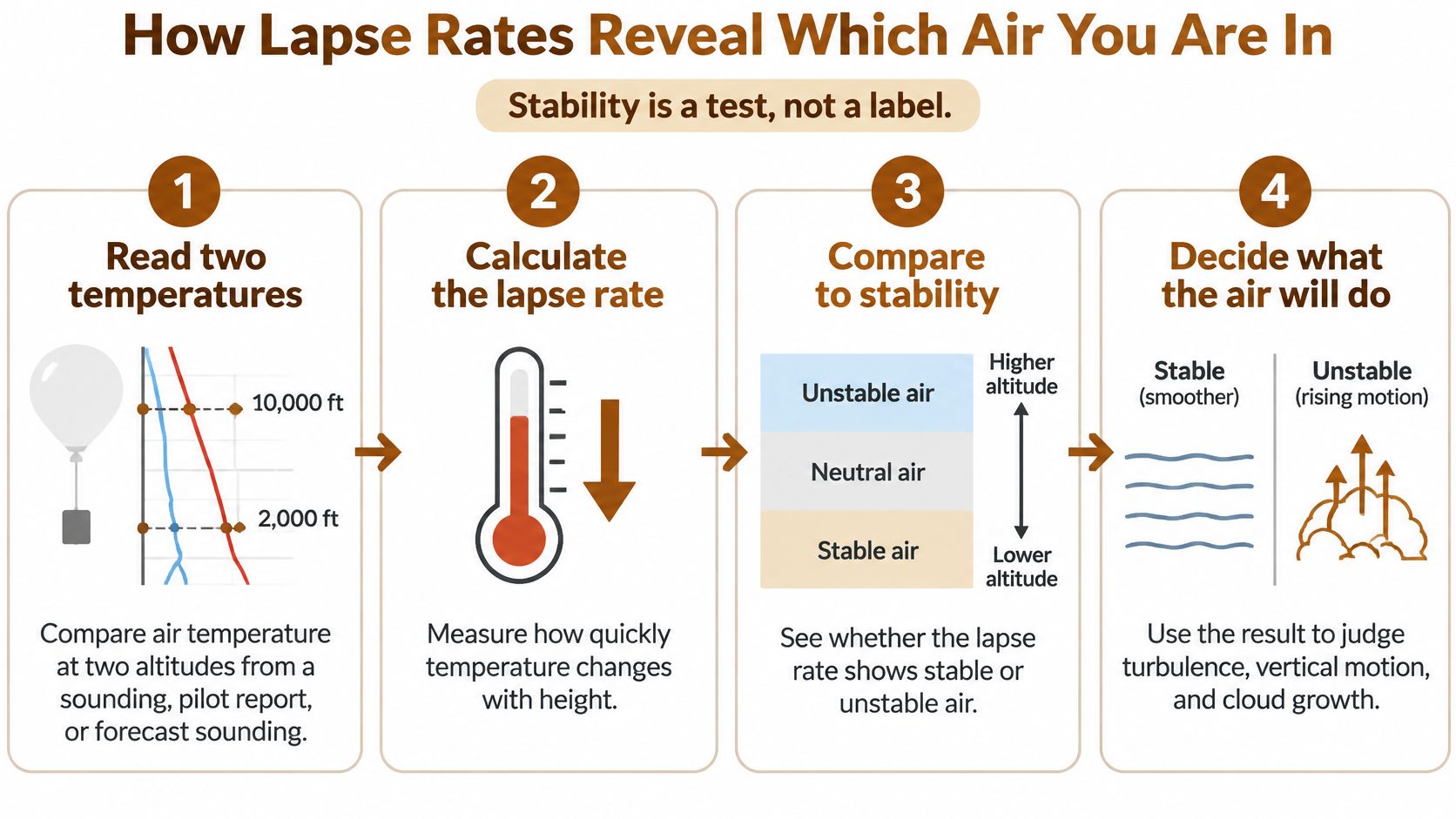
The three bands are worth memorizing. Absolutely stable means the environmental lapse rate is less than the moist adiabatic rate. Absolutely unstable means it is greater than the dry adiabatic rate. Conditionally unstable means it falls between the two. The dry adiabatic rate is about 9.8°C per kilometer, or 3°C per 1,000 feet, for unsaturated rising air. The moist rate is lower because condensation releases latent heat, and it varies with temperature and pressure.
Run the test in order
- Read two temperatures. Take the air temperature at two altitudes from a sounding, a pilot report, or a forecast sounding. One number cannot tell you the slope.
- Find the environmental lapse rate. Subtract the upper temperature from the lower one and divide by the height between them, in thousands of feet. That is the actual cooling of the layer, not a textbook constant.
- Compare it with dry air. Unsaturated rising air cools at about 3°C per 1,000 feet. If the layer cools faster than that, a dry parcel stays warmer than its surroundings and keeps rising.
- Compare it with saturated air. Once the parcel saturates, latent heat slows the cooling. The moist rate is lower than the dry rate, and it shifts with temperature and moisture. Warm saturated air releases more latent heat as it condenses, so its cooling slows more than cold saturated air. A layer that looks quiet while dry can turn buoyant after clouds form when its lapse rate is steeper than the moist rate.
- Name the layer. Below the moist rate is absolutely stable. Between the rates is conditionally unstable. Above the dry rate is absolutely unstable.
| Reference | Rate | Use in classification |
|---|---|---|
| Dry adiabatic rate | About 3°C per 1,000 ft (9.8°C per km) | Threshold above which a layer is absolutely unstable |
| Moist adiabatic rate | Lower than the dry rate; varies with temperature and moisture | Threshold below which a layer is absolutely stable |
Say a layer loses 4°C over 2,000 feet. That is 2°C per 1,000 feet. The layer cools more slowly than the dry rate, so a dry parcel rising through it becomes cooler than the surrounding air and settles back. The layer is stable while the air is dry. If the parcel saturates and the layer's lapse rate is steeper than the moist rate for that temperature, the parcel cools more slowly than its surroundings and can keep rising. That is the flight-planning warning: a steep lapse rate plus moisture supports vertical growth. The same comparison shows up again when you work aviation weather theory problems on a knowledge test.
How Stability Changes From Morning to Afternoon
The same valley can be smooth at sunrise and bumpy after lunch. Stability isn't a fixed label on the air mass. It shifts with the clock because the surface temperature changes and the lapse rate in the lowest layer changes with it.
The National Weather Service stability and clouds briefing puts the dry-adiabatic rate at approximately 10°C per kilometer and the moist-adiabatic rate at about 6°C per kilometer. A layer can sit on one side of those lines before saturation and on the other side after it. That spread is why a morning inversion and an afternoon cumulus field can belong to the same airport on the same day.
A valley timeline
Overnight, the ground loses heat. The air next to it cools, a surface inversion forms, and vertical motion dies. Winds are often light. If the air is moist, fog or haze collects in the valley and a stratus layer can cap the field.
At 7 a.m. that valley ride is smooth and milky, with stratus based near 1,500 feet. Sunlight then warms the ground. The lowest few hundred feet warm first, the inversion erodes from the bottom, and the lapse rate in that shallow layer steepens. Parcels start to rise as thermals. They climb until they reach the condensation level, cloud bases appear, and further rise follows the slower moist cooling.
By 1 p.m. the same valley shows cumulus with tops near 4,000 feet and a bumpy layer underneath. Nothing about the "air mass name" had to change. The surface heated, the inversion broke, and a lifting mechanism, daytime heating over the valley floor and the slopes, was now available.
What you decide before you start
One classification can't cover the whole flight. The layer at 1,000 feet, the layer at 6,000 feet, a moist pocket, and a dry pocket can each give a different answer. Terrain adds lift on the windward side of a ridge that a flat departure path never sees.
Compare the morning observation with the afternoon forecast before you accept the airplane. If cumulus is the expected result of surface heating, pick a departure that finishes the pattern work before that heating is established, and expect a rougher ride once the afternoon build starts. If you must fly later, brief the bumpy segment as its own problem, not as a surprise.
Inversions and Why Smooth Air Can Still Be Hazardous
Smooth air is not the same thing as a safe departure. Students hear "stable" and picture an easy ride. The layer can be glassy and still hand you a wind change, a visibility trap, or both, right when you're low and slow.
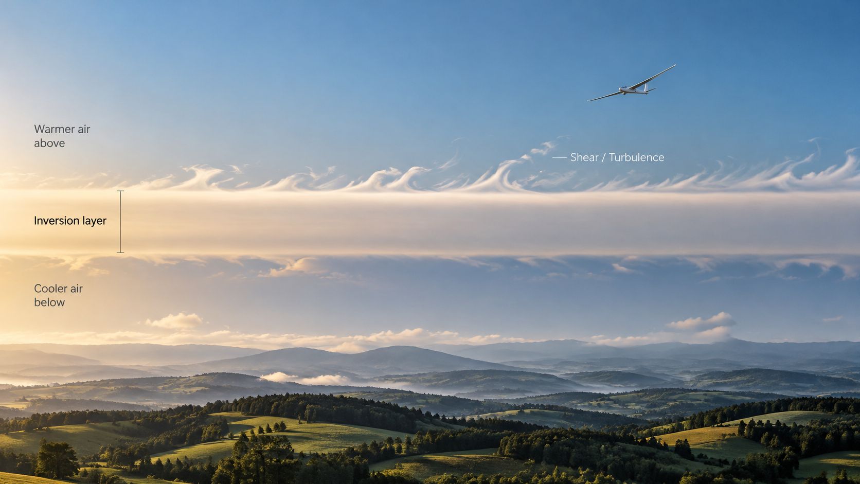
An inversion is a layer where temperature increases with altitude. The FAA's Aviation Weather advisory circular describes inversions as strongly stable, with little turbulence inside the layer itself. Unstable air tends to make larger eddies that break up quickly. Stable air tends to make smaller eddies that hang on longer. The calm look of the layer doesn't cancel the boundary.
The dawn valley departure
Say you launch at dawn from a valley airport. The surface wind is nearly calm. Above the inversion, the wind is 20 knots from the west. On the climb you cross that boundary. Heading, airspeed, and climb rate can all shift in a short vertical distance because the wind changed, not because a thermal grabbed the wing. The same shift is waiting on the way down if you descend back through it on the approach.
Inside the inversion, mixing is weak, so haze, smoke, and other pollutants stay trapped underneath. Visibility can be poor even though the airplane isn't bouncing, and the ceiling can sit lower than the clear sky above the layer suggests. Stable air favors those layered clouds and that trapped murk. Unstable air favors vertical growth and turbulence you can see coming in the cloud shape.
Watch how a temperature trace and a wind change line up on a simple sounding in this short briefing.
If the air looks smooth, still read the winds above the inversion before you release the brakes.
Before engine start, look at winds aloft and any temperature profile you can get. If temperature rises with height, mark the altitude of that layer. Plan the climb with airspeed margin so a sudden tailwind or headwind doesn't put you behind the power curve. Expect the change near the base and the top of the inversion, not in the middle of a long, quiet cruise.
Hazards by Phase of Flight
What does each air type mean for the phase you're about to fly? Read the row for that phase. Don't carry one label from the ramp all the way to the destination.
| Phase of flight | Stable air hazard | Unstable air hazard |
|---|---|---|
| Takeoff and initial climb | Low ceiling and haze; wind change above a surface inversion | Gusty convective air; cumulus building near the departure path |
| Climb through an inversion | Abrupt wind shift and low-level shear at the inversion base or top | Updrafts and downdrafts that change climb rate |
| Cruise | Layered clouds and restricted visibility; trapped smoke or haze | Embedded cumulus and convective turbulence; cumulonimbus to avoid |
| Landing | Low ceilings and reduced visibility; wind change near the inversion | Gusts from storm outflow; showers and lightning reducing visibility |
Use the row before you start
- Classify the layer you'll fly through, using temperatures at two heights rather than the look of the ramp alone.
- Name the next phase. Takeoff, the climb through a marked inversion, cruise, and landing are separate problems.
- Read that row out loud and name the hazard you'll plan for. A stable landing is a ceiling and visibility problem. An unstable landing is a gust and shower problem.
- Set the decision before start. A later departure, a different altitude, or an alternate is useful only if you choose it while you're still on the ground.
Stable air still resists vertical motion, and it can still bring a low ceiling, trapped haze, and shear where the wind changes across an inversion. Unstable air brings convective bumps, showers, lightning, and gusty outflow near storms that are still building. A single cross-country can cross both. The climb out of a valley can leave a stable surface layer and enter a conditionally unstable layer aloft, then the arrival can drop you back into haze. Check each phase on its own instead of picking one word for the route.
Briefing Signals and the Pre-Flight Stability Check
The products you already pull will tell you which row you're in if you read them for stability, not only for wind and ceiling.
Start with the METAR. Temperature and dew point are the moisture clue. A narrow spread means the air is close to saturation, so cloud and visibility can change quickly once any lift appears. Then read the TAF. Showers, thunderstorms, and tempo or prob groups that add cumulus weather point to unstable air later in the window, even if the current METAR is calm. The area forecast discussion and recent pilot reports add turbulence and where convection is already going. Winds aloft, and a sounding if you have one, show an inversion when the temperature rises as you go up, or when the wind jumps between two nearby levels.
| Briefing signal | Air type it points to | Planning action |
|---|---|---|
| Stratus or fog with low visibility in METAR and TAF | Stable and moist | Confirm ceiling and visibility against VFR minimums; set an alternate |
| Smooth, hazy layer after dawn with light surface wind | Surface inversion, stable | Check winds aloft; expect a wind change at the inversion during climb or descent |
| Cumulus building by midday with showers in the TAF | Unstable and moist | Plan an earlier departure; expect convective turbulence after midday |
| Cumulonimbus or thunderstorms in the forecast | Strongly unstable | Do not depart into developing convection; delay or reroute |
| Clear, cool, dry morning with a narrow temperature range | Stable and dry | Expect smooth air; watch for fog if the dew point spread narrows |
| Temperature rising with height on a sounding | Inversion, strongly stable | Expect suppressed convection and trapped haze; check visibility limits |
Don't brief off a single clue
Confirm two or more signals before you decide the day is stable or unstable. A hazy METAR plus a sounding that warms with height is a stable, inversion case. Building cumulus plus showers in the TAF is an unstable, moist case. When low visibility and cumulus growth show up in the same area, treat the flight as a changing-condition day and plan a smooth segment and a bumpy segment, with a point where you'll turn back.
Three questions before every training flight
Answer these in this order.
- Is the air likely stable or unstable at my planned altitudes? Use the lapse-rate test on the layer you'll climb through, not a guess from the ramp.
- Is there an inversion between the surface and the climb or descent? If yes, brief the altitude and the wind change.
- Do the TAF and the area forecast show convection on my route or in my time window? If yes, move the window or the route before you start.
Write the three answers as one line in the flight log. After the flight, compare that line with the ride you got. That habit is what turns a memorized definition into a check you can use on a knowledge test and on a solo. Our question set is updated monthly as the FAA changes questions and the ACS evolves, and flyCowboys provides detailed, plain-English explanations for every single question, including the weather items that pair a lapse rate with a cloud type. The same preflight habit fits the tools in our roundup of aviation apps for weather and briefing.
The one-line plan is simple. Classify the air, check for an inversion, and decide the departure window before engine start.
Stable vs unstable air shows up on every private and instrument written, and the questions reward the pilot who can tie a lapse rate to a cloud, a ceiling, or a shear layer. flyCowboys pairs those weather items with plain-English explanations inside an ACS-mapped iPhone question bank, so you can practice the exact distinction before the checkride oral. When you're ready to drill it, visit flyCowboys.