· 21 min read
Airspace Classifications Explained for Student Pilots
Airspace classifications explained for student pilots: Class A through G limits, VFR cloud rules, radios, and the check that decides if you can fly there today.
You've drawn a line across the sectional for your next cross-country, and your instructor points to a dashed blue boundary. Beyond it are magenta shading, a stack of solid blue shelves, and a military operations area near your route. You can name some of the colors, but you're still deciding whom to call, how high to fly, and whether the route is usable today.
That's where airspace classifications explained as a flying task, rather than an alphabet exercise, becomes useful. Start with the airplane's position and altitude. Then check weather, communications, equipment, and current restrictions, because a class label alone isn't permission to enter.
Table of Contents
- Class A Through G at a Glance
- Reading Floors Ceilings and Shelves
- VFR Weather Minima and IFR Access
- Radios Transponders and ADS-B
- Special Use Airspace TFRs and TRSAs
- A Student Cross Country Through Four Classes
- Who Grants Access and the Preflight Check
Class A Through G at a Glance
You depart a towered training airport and climb toward cruise. Without any obvious change outside the windshield, you can leave the tower's airspace, enter the surrounding controlled airspace, and approach a shelf protecting a major airport. The airplane hasn't changed, but your obligations have.
The FAA's restrictiveness ladder runs A, B, C, D, E, then G, and its Aeronautical Information Manual airspace overview describes typical limits of 18,000 feet MSL through FL600 for Class A, surface to 10,000 feet MSL for Class B, surface to 4,000 feet above airport elevation for Class C, and surface to 2,500 feet above airport elevation for Class D.
U.S. airspace classes for student pilots
| Class | Typical vertical limits | Chart clue | VFR entry |
|---|---|---|---|
| A | High-altitude airspace through its published upper limit | Not depicted as a surface area on a VFR sectional | Normal operations require IFR |
| B | Surface core with elevated outer shelves | Solid blue lines | Explicit ATC clearance addressed to your aircraft |
| C | Surface core and an outer shelf | Solid magenta lines | Establish two-way radio communications before entry |
| D | Surface area around an operating tower | Dashed blue line | Establish two-way communications with the tower before entry |
| E | Surface or an elevated floor, extending to the next overlying class | Dashed magenta, shading, or no local boundary marking | No clearance required for ordinary VFR operations |
| G | Airspace below or outside designated controlled airspace | Usually identified by finding the overlying controlled-airspace floor | No ATC contact required by class alone |
Read the classes as operating environments
Class A is the high-altitude IFR environment. FL600 is a flight level based on standard pressure, not an altimeter reading using the local setting. For a student planning a VFR cross-country, treat Class A as outside the operating plan.
Class B surrounds the busiest airports. Its shelves allow aircraft to operate beneath portions of the protected arrival and departure airspace, but speaking to a controller doesn't by itself authorize entry. You need an explicit Class B clearance.
Class C combines a towered airport with radar approach services. Call the appropriate facility before reaching its boundary and establish two-way communications. Don't confuse a controller's acknowledgment with a landing clearance, which is a separate authorization.
Class D generally protects the operating environment around a towered airport. The tower needs to know who you are and what you intend to do before you enter. An airport's tower status matters, so check published operating information rather than assuming yesterday's arrangement still applies.
Why E and G deserve equal attention
Class E is controlled airspace that isn't designated A, B, C, or D. You can be flying VFR there without talking to anyone while another aircraft operates on an IFR clearance nearby.
Class G is the remaining uncontrolled airspace. Uncontrolled describes the airspace classification, not freedom from weather rules, right-of-way obligations, or flight restrictions.
Practical rule: Identify the class occupied by the airplane, not merely the class associated with the nearest airport.
There's no active U.S. Class F in this lookup. Use the table as a quick identification card, but use the published chart and current information to determine the actual boundaries.
Reading Floors Ceilings and Shelves
On a sectional, one point along your route can sit beneath a shelf while another, just a short distance away, lies inside it. The airspace above the route works like a stack of layers, each with its own horizontal boundary and vertical limits.
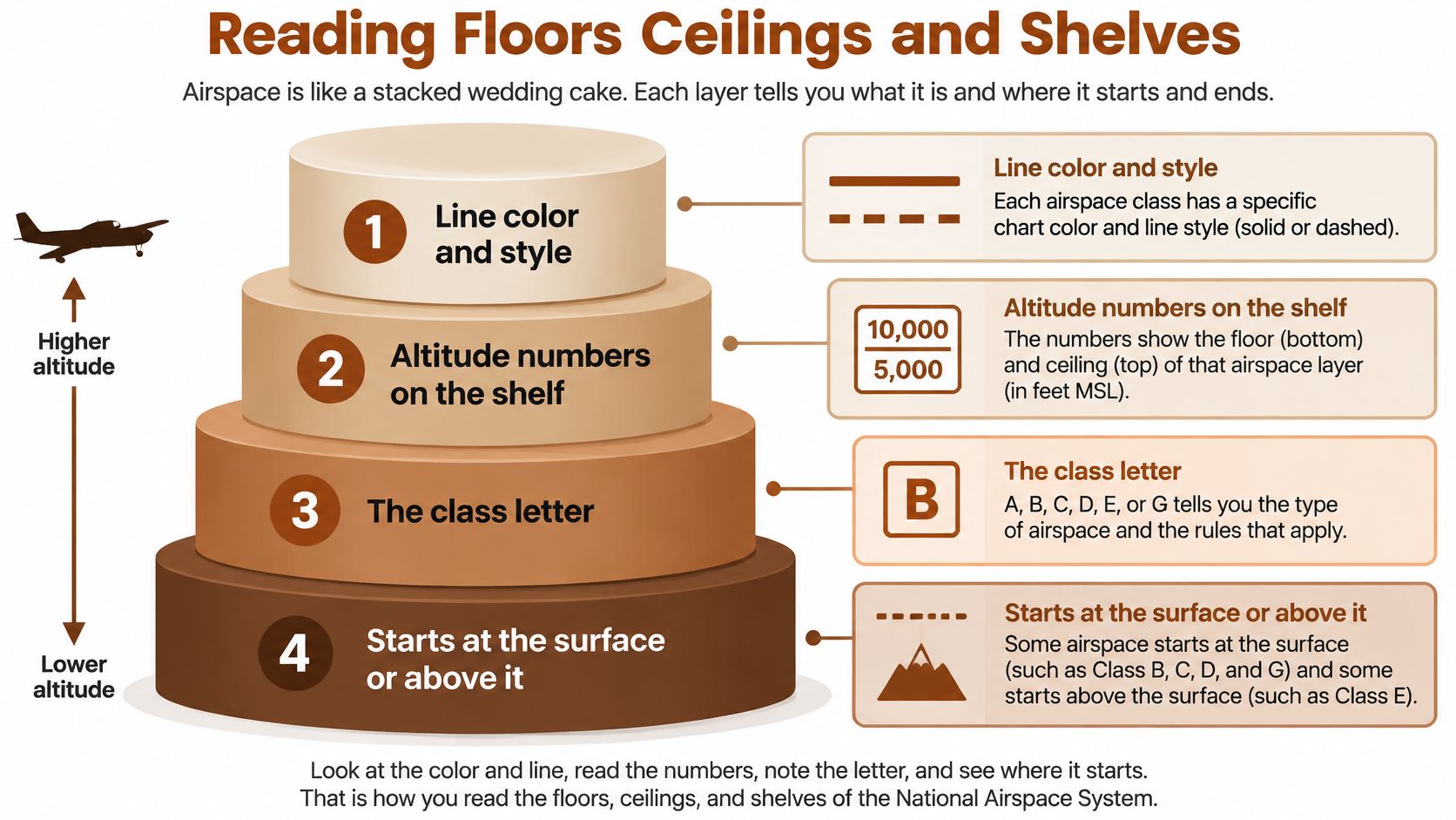
Read the boundary before the altitude
At each boundary along your route, work through these steps:
- Color and style. Identify the solid blue or magenta boundary, dashed line, or shaded area.
- Altitude label. Read the floor and ceiling for that specific sector.
- Altitude reference. Check whether the figures refer to mean sea level, height above ground, or height above airport elevation.
- Inside and outside. Trace which side of the boundary contains the airspace you're checking.
Crossing a shelf's outline on the ground does not necessarily put you inside that class. Your altitude must also fall within the shelf's vertical limits.
For example, suppose a shelf label reads 100 over 40. Charted altitude figures are in hundreds of feet, so this indicates a ceiling of 10,000 feet MSL and a floor of 4,000 feet MSL. An airplane below 4,000 feet MSL has not entered that shelf, even if it has crossed the shelf's outline.
Compare the shelf with the terrain
A typical Class C design has a surface core with a 5-nautical-mile radius and an outer shelf extending to roughly 10 nautical miles, commonly from 1,200 to 4,000 feet above airport elevation. These dimensions are described in the FAA Aeronautical Information Manual's Class C airspace guidance. Individual designs vary, so use the chart for the actual boundaries and altitudes.
Class E shading calls for a different check. If the floor is expressed in AGL, measure its height from the terrain. If an airport airspace ceiling is charted in MSL, use that altitude reference rather than adding the ceiling to the airport elevation.
A dashed magenta boundary identifies surface Class E. A magenta vignette indicates a higher Class E transition area, with the shaded side showing the lower-floor area. Check the sectional legend to distinguish the symbols. For instrument-chart conventions, see this guide to reading IFR chart symbols.
Try a tracing drill: Pick a point on your route and identify each boundary around it. Work upward from the terrain: name the class below the airplane, the class containing it, and the next shelf above. If any boundary or altitude remains unclear, resolve it before departure.
VFR Weather Minima and IFR Access
A cloud base 1,000 feet above your airplane may appear to leave room for VFR, but the legal minimum depends on the airspace, altitude, time of day, and aircraft category. Start by identifying those conditions, then apply both visibility and cloud-clearance requirements.
Basic VFR weather minima by class and altitude
| Where you are | Visibility | Cloud clearance |
|---|---|---|
| Class B, any altitude | 3 statute miles | Clear of clouds |
| Class C or D | 3 statute miles | 500 feet below, 1,000 feet above, and 2,000 feet horizontally |
| Class E below 10,000 feet MSL | 3 statute miles | 500 feet below, 1,000 feet above, and 2,000 feet horizontally |
| Class E at or above 10,000 feet MSL | 5 statute miles | 1,000 feet below, 1,000 feet above, and 1 statute mile horizontally |
| Class G by day, at or below 1,200 feet AGL | 1 statute mile | Clear of clouds |
| Class G at night, at or below 1,200 feet AGL | 3 statute miles | 500 feet below, 1,000 feet above, and 2,000 feet horizontally |
| Class G by day, above 1,200 feet AGL and below 10,000 feet MSL | 1 statute mile | 500 feet below, 1,000 feet above, and 2,000 feet horizontally |
| Class G at night, above 1,200 feet AGL and below 10,000 feet MSL | 3 statute miles | 500 feet below, 1,000 feet above, and 2,000 feet horizontally |
| Class G at or above 10,000 feet MSL, more than 1,200 feet AGL | 5 statute miles | 1,000 feet below, 1,000 feet above, and 1 statute mile horizontally |
The FAA's summary of basic VFR weather minimums lays out the Class B through G requirements. For more on the conditions behind these rules, see this guide to aviation weather theory.
Choose the row before choosing the route
For Class G, check the time of day, height above ground, altitude MSL, and aircraft category before selecting a minimum. The AGL and MSL figures answer different questions: AGL measures height above the terrain, while MSL uses the altimeter reference. A permissive daytime minimum in one band does not apply automatically at night or higher up.
Cloud clearance includes space beside the airplane, not only beneath a cloud layer. Visibility and cloud distance are separate requirements, and both must be met.
Check weather at the airport as well as along the route. VFR takeoff, landing, or pattern entry in designated controlled surface areas has a ground-visibility requirement. Flight visibility applies in the circumstances specified by the rules when ground visibility is not reported.
Weather permission isn't entry permission
At 3,500 feet MSL beneath a uniform cloud base at 4,500 feet MSL, you have 1,000 feet of vertical separation. That alone does not establish legal VFR: check visibility and clearance from nearby clouds, too.
In Class B, being clear of clouds does not grant access. In Classes C and D, meeting the weather minimum does not establish the required communications. A route can meet the VFR weather rules and still require a separate entry condition.
Legal weather, legal access, and a sensible safety margin are separate decisions. Your flight needs all of them.
An IFR clearance does not let a student pilot use IFR as a workaround for poor VFR conditions. IFR flight requires the appropriate pilot qualifications, aircraft capability, and ATC authorization. Certificate privileges and student endorsements can also limit a flight beyond the airspace's basic entry rules.
Radios Transponders and ADS-B
Your chart tells you where the boundary lies. Your radio exchange tells you whether the communications or clearance condition has been met. Keep those tasks separate, and make the initial call early enough that a busy frequency won't push you across the line.
A useful first call gives facility, aircraft identification, position, and request. In a practice script, that might be: Riverton Tower, Cessna November Alpha Bravo, east of the airport, inbound with the current information. Substitute your actual identification, position, and intentions rather than memorizing a fictional call.
Listen for the part that changes your status
For Class C or D, the important acknowledgment is your aircraft identification. A response addressed only to the aircraft calling doesn't establish the same two-way contact as a response addressed to you.
A standby instruction containing your call sign can establish communications, but an accompanying instruction to remain outside still controls. Don't isolate a familiar word from the rest of the transmission.
For Class B, acknowledgment isn't enough. Listen for an explicit clearance into the Class B, addressed to your aircraft, and read back the relevant clearance and instructions.
| What you hear | What to do |
|---|---|
| A general reply without your identification | Remain outside while establishing contact |
| Your identification and a standby instruction | Recognize the acknowledgment, then comply with any entry restriction |
| A transponder code assignment | Set the code, but don't treat it as a Class B clearance |
| An explicit Class B clearance | Read it back and follow its limits |
Our radio procedure guide provides another way to practice the sequence before you're managing the airplane and frequency together.
Check equipment across the whole route
A radio, transponder, and ADS-B Out perform different jobs. The radio supports communications. A transponder supports surveillance and identification. ADS-B Out broadcasts aircraft information for surveillance; ADS-B In traffic displayed on a tablet isn't a substitute.
Check equipment requirements against every airspace volume you'll occupy, including areas beneath shelves. A Class B equipment veil can affect an airplane that never enters Class B. Class D alone doesn't automatically impose the same surveillance-equipment requirements as Class C.
Use a short equipment card:
- Installed capability. Confirm what the aircraft has, rather than relying on the tablet display.
- Operating condition. Check required equipment status and the aircraft's maintenance information.
- Route overlap. Inspect veils, shelves, and altitude-related requirements.
- Exceptions or deviations. Resolve any applicable authorization before departure, not at the boundary.
Don't infer speed limits from the class letter either. In particular, a blanket claim that the lower terminal-area speed restriction applies everywhere inside Class B is misleading. Check the applicable operating rule for the precise location.
If communications fail, don't adopt a universal instruction to leave immediately by any convenient route. Apply the relevant lost-communications procedures, maintain predictable flight, and follow applicable clearances and tower signals.
Special Use Airspace TFRs and TRSAs
Your route remains outside the busy airport's shelves, and the weather looks suitable. Then a current notice shows a restriction across the next leg. You identified the underlying class correctly, but you still can't assume the route is available.
The FAA's airspace guidance distinguishes regulatory and nonregulatory areas and warns that temporary restricted areas and temporary military operations areas may not appear on charts. A current NOTAM and activation check therefore belongs alongside the sectional, not after it.
Use the flow as a decision process, rather than a list of symbols to memorize.
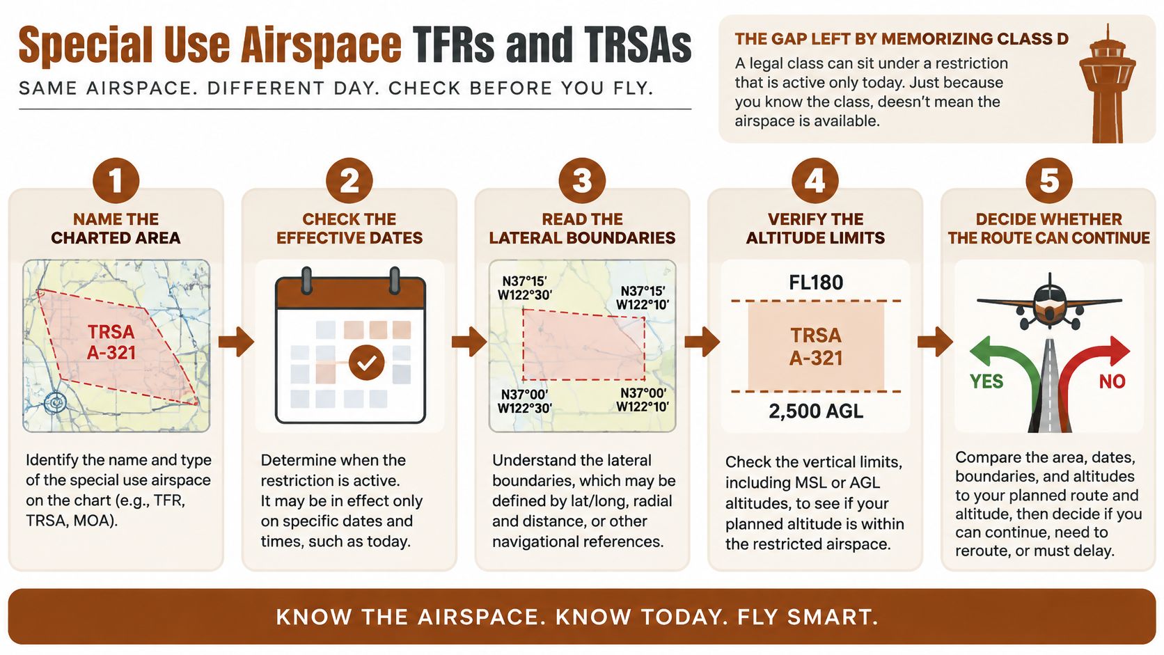
Make the current-access decision
- Name the charted class and floor. Establish where the airplane would fly.
- Inspect special-use airspace. Check the route and nearby alternatives, including vertical limits.
- Read NOTAMs and TFRs. Review effective times, boundaries, exceptions, and the restriction's wording.
- Verify activity. Use published information and the controlling agency or ATC where appropriate. Don't assume scheduled hours prove current status.
- Decide whether entry is permitted. Continue only when the applicable conditions are satisfied, or choose another route.
Read the full notice. A shaded overlay is useful for locating a restriction, but it may not communicate every exception, authorization condition, or operational limitation.
Distinguish prohibition from caution
Prohibited and restricted areas are regulatory. Treat prohibited areas as unavailable to your planned flight unless the required authorization applies. Restricted-area entry requires attention to activity status and authorization from the appropriate agency.
Military operations areas, or MOAs, identify military training activity. Ordinary VFR transit isn't automatically forbidden, but legal access doesn't make an active training area a good shortcut. Ask about activity and consider routing around it; flight following doesn't guarantee separation from every participating aircraft.
Warning areas identify potentially hazardous activity over offshore waters. Alert areas highlight unusual activity or concentrated training. Controlled firing areas use procedures to suspend hazardous activity when nonparticipating aircraft approach, while national security areas generally request avoidance unless a separate mandatory restriction applies.
Route-planning test: If your decision depends on an area being inactive, write down how you'll verify that assumption and what you'll do if it's active.
Recognize a TRSA without inventing another class
A Terminal Radar Service Area, or TRSA, isn't Class C under another name. Its sectional boundaries are depicted with solid black lines, not the solid magenta used for Class C.
VFR participation in TRSA radar services is voluntary, but the underlying airspace requirements remain applicable. Declining radar service doesn't let you enter an underlying tower-controlled area without the required communications.
Current checks matter around disaster response, presidential movement, space operations, and major public events. Before your next solo, run the decision process on a single planned leg and identify an alternate that doesn't depend on the questionable area being available.
A Student Cross Country Through Four Classes
Consider a hypothetical daytime solo from a nontowered home field to a Class C destination. The route passes a towered satellite airport, skirts a MOA, and approaches an area influenced by a neighboring Class B airport.
The view outside may remain rural even as your operating obligations change.
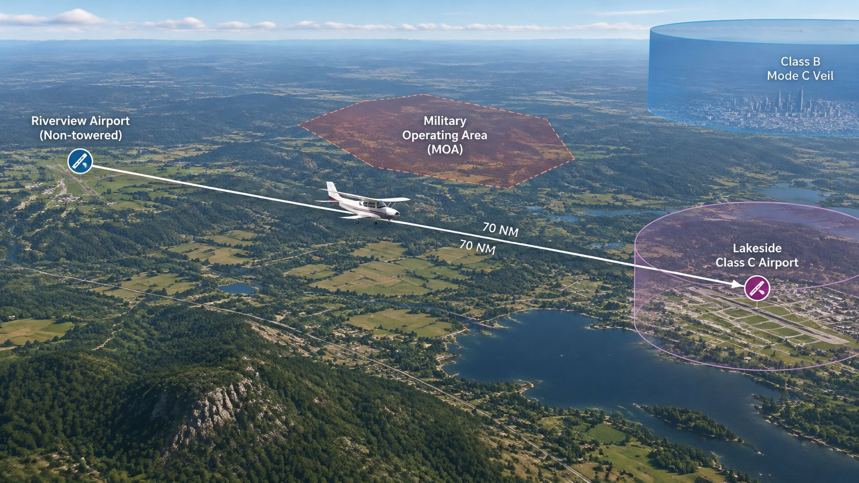
Departure and the first transition
At the home field, your planning confirms that the pattern lies below a higher controlled-airspace floor. You're in Class G, using the airport's published traffic procedures and CTAF. The absence of a tower doesn't eliminate the need to listen, announce intentions, and watch for aircraft that may not transmit.
During the climb, you pass the charted floor and enter Class E. No controller announces the transition, and there's no required VFR handoff. You've already selected the correct weather requirement during planning, so you don't discover a cloud-clearance problem after climbing into it.
The satellite airport appears ahead. Before reaching its dashed blue boundary, you call the tower with your position and transit request. The controller acknowledges your aircraft and issues instructions, which you follow while crossing Class D.
After the transit, you obtain the appropriate frequency change. Don't assume the tower has arranged radar service for the remainder of your flight unless that coordination is provided.
The MOA and destination arrival
Near the MOA, you ask the controlling facility about activity. If the status remains uncertain, you use your planned offset rather than turning uncertainty into permission. You also check that the offset won't create a new conflict with terrain or another shelf.
Approaching the destination, you contact approach before entering the relevant solid magenta boundary. You listen for your identification, comply with instructions, and enter Class C only after satisfying its communications requirement.
A code assignment helps the controller identify you, but your decision isn't based on the code alone. You continue listening for altitude, sequencing, and frequency instructions while maintaining visual awareness.
Use this video as a second rehearsal, pausing to identify what the pilot needs before each boundary.
Rehearse the return before landing
The neighboring Class B shelf stays above your arrival and go-around plan, but you've checked its equipment-related implications separately. A go-around isn't permission to climb through a shelf, so brief both the aircraft maneuver and the airspace above it.
For a night return, reassess the home-field pattern rather than copying the daytime weather decision. The same ground location can require a different Class G weather analysis after dark.
Retell the communications in sequence:
- Home-field CTAF. Coordinate with local traffic.
- Satellite tower. Establish contact for the transit.
- Radar facility. Request advisories and activity information.
- Destination approach, then tower. Follow the arrival handoff and landing instructions.
Who Grants Access and the Preflight Check
A common misunderstanding sounds reasonable: controlled airspace means you need a clearance, and ATC will separate you from everyone. Neither assumption works across all controlled classes.
The FAA's controlled-airspace and UAS guidance describes controlled airspace as Classes A through E, with services provided according to the applicable classification. It also identifies special-use-airspace information available through charts and drone-oriented applications such as B4UFLY and LAANC.
Controlled describes the operating framework, not a universal service package. You need to know both what allows entry and what service ATC provides once you're there.
Separate authorization from service
Compare VFR aircraft flying at a similar altitude in different places. A pilot operating in Class B receives a different separation service from a pilot in Class C. A pilot in Class E may legally be operating without any ATC contact at all.
Requesting flight following doesn't convert surrounding Class E into Class B service. Nor does a traffic display make every nearby aircraft visible, identified, or separated. Keep scanning and understand the limits of the service you're receiving.
| Planning question | What answers it |
|---|---|
| May I enter this volume? | The applicable class rule, current restrictions, pilot privileges, and authorization |
| Who should I contact? | Published facility information and the procedure for that location |
| What service will I receive? | The airspace classification and service actually being provided |
| What remains my responsibility? | Applicable operating rules, compliance with instructions, and visual responsibilities |
Class G is uncontrolled, not unregulated. A TFR can affect it, weather rules still apply, and pilots still have right-of-way responsibilities. Leaving controlled airspace doesn't remove those obligations.
The same location can involve different authorization systems
A drone operator and a student flying an airplane shouldn't use each other's access assumptions. Drone operations can involve controlled-airspace authorizations through LAANC or another FAA process, while the airplane pilot uses the applicable communications and clearance procedures.
A drone application's airspace display is useful within that operator's workflow. It isn't a substitute for your aircraft's chart, briefing, or ATC requirements. Conversely, an airplane pilot's ability to fly VFR without contact in an area doesn't establish that a drone operation there needs no further review.
The U.S. framework also isn't a worldwide permission system. International pilots must consult the controlling state's Aeronautical Information Publication, national rules, and current notices. Familiar colors or class letters aren't enough to assume identical privileges abroad.
Build a departure-ready card
Put decisions on the kneeboard, not just definitions in your notes.
- Trace the route vertically. Mark each class you'll enter, the shelf above, and a practical altitude margin. Include departure, arrival, diversion, and go-around paths.
- Match weather to location and time. Select the applicable class and altitude band, then check departure and destination surface requirements. Apply personal minimums above the legal baseline.
- Prepare communications and equipment. Write the facility, frequency, first call, and entry condition. Confirm surveillance-equipment requirements across the complete route.
- Resolve temporary and special-use restrictions. Record effective times, activation status, and any authorization needed. Distinguish optional radar service from mandatory underlying-airspace requirements.
- Choose the fallback. If weather, access, equipment, or communications won't support the plan, change the route, altitude, departure time, or destination before takeoff.
Don't leave a blank labeled ask ATC and assume the controller will solve it airborne. ATC can help with operational requests, but you remain responsible for launching with a workable, legal plan.
For a useful study drill, close the sectional and redraw tomorrow's route from memory. Name each transition, explain what you must hear before crossing, and identify where a temporary restriction could invalidate the plan. Then reopen the chart with your CFI and correct the gaps.
Our airspace practice at flyCowboys pairs exam questions with plain-English explanations written by real CFIs, so you can connect chart symbols with entry and weather decisions. Choose PPL or IFR and take the short placement quiz to build a personalized study plan around your weak areas, then bring those questions to your next sectional briefing.